2A MacCurtain Street, Cork

PROJECT OVERVIEW
2A MacCurtain Street is located in Cork’s Victorian Quarter, a busy urban area with historic streetscape character and protected building fabric.
AltiGeo was appointed to carry out a high LOD survey of the protected structure elements that were to be retained as part of the proposed works.
Areas scheduled for demolition required a lower level of detail, allowing the survey and modelling scope to be tailored efficiently to the client’s requirements.
Survey Methodology
Due to the busy city-centre location, external scanning was carried out early in the morning between 5:00am and 7:30am to reduce disruption and improve scan quality.
Black and white targets were strategically placed to establish survey control, with survey nails installed in areas expected to remain unaffected during construction. A Leica total station was used to observe and record the precise coordinates of the scan targets and survey nails, creating a robust control network for the survey.
A total of 38 external scans were captured using the Leica RTC360. The control observations allowed the scan data to be accurately registered, georeferenced and coordinated across the site.
To improve efficiency, only the scans around the protected structure were colourised with 360° imagery. Lower-detail areas were captured without colour imagery.
Internal Survey
The internal areas were partly demolished at the time of survey. Across the full project, 145 scans were completed using the Leica RTC360.
The scanner’s high-speed, high-density data capture allowed the team to accurately record exposed walls, retained structure elements and adjoining wall conditions and placement, creating a reliable digital record of the existing building fabric.
The setups were then registered in Cylcone Register 360 Plus.
Drone Survey
A drone survey was also carried out to capture adjoining walls, elevated areas and parts of the site not clearly visible from the ground-based LiDAR scans.
The resulting online viewable 3D model helped the design team and engineers understand the site context, existing conditions and relationship with surrounding structures.
Drone Survey Planning
The site was located within overlapping controlled airspace, including the Temporary BVLOS Cork Area T2, Cork Control Zone and Manna BVLOS Area.
AltiGeo submitted a UF101 application to AirNav Ireland five days before the survey. Approval was received two days before the flight, subject to operational conditions including altitude limits, visual line of sight, ATC notification and coordination with Manna Operations.
On the day of the survey, Cork Air Traffic Control and Manna Operations were contacted before and after the UAS activity, ensuring the flight was carried out safely and in line with the approved conditions.
Project Outcome
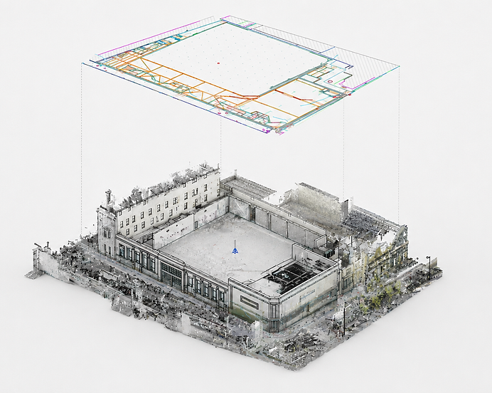
The completed survey provided the client and design team with a clear and accurate digital record of the protected structure and surrounding site.
By applying different levels of detail to retained and non-retained areas, AltiGeo delivered an efficient survey package that supported conservation review, design coordination and future construction planning.
Scope of Services
The project combined terrestrial laser scanning, drone survey, CAD production and BIM modelling to accurately capture the retained heritage elements, adjoining walls and surrounding site context.
Deliverables
-
Geolocated and controlled pointcloud
-
LOD 300 CAD drawings & BIM Model of protected structure elements
-
LOD 200 CAD drawings & BIM Model of adjoining walls and non-retained areas
-
Drone survey and online viewable 3D model